
New online tool helps Whakatāne district communities understand climate risks
24 Mar 2026
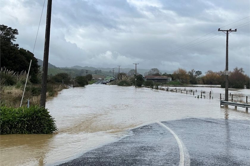
Media release | Whakatāne District Council has released a new online mapping tool to help people better understand how climate change and climate-related hazards could affect different parts of the district, now and into the future.
Called Adaptation Explorer, the tool is an interactive digital map that shows general areas that may be exposed to climaterelated hazards such as flooding, landslides, coastal erosion, sea level rise and extreme heat.
People can type in an address and explore different climate-related hazards and risks across the district. The tool is designed to support learning, awareness and early planning, rather than provide property-specific answers.
Lou Hunt, Climate Change and Resilience Manager at Whakatāne District Council, says Adaptation Explorer is about helping communities understand risk earlier so they can respond.
“Climate change isn’t something we’re expecting to happen one day, it’s already affecting parts of our district,” says Hunt. “Adaptation Explorer helps make that information easier to see and easier to talk about.”
Adaptation Explorer has been developed as part of the Council’s wider Climate Change Adaptation Programme, which is based on the Whakatāne District Climate Change Risk Assessment completed in 2025. The assessment was prepared by Tonkin and Taylor and Council staff and involved more than 800 people, including iwi, hapū, community groups and technical experts.
Hunt says its important people understand what the tool is, and what it is not.
The maps show climate-related hazard areas across the district, and the risks communities have observed. They don’t assess risk for individual homes or buildings,” she says. “It’s a guide to help start conversations and ask the right questions.”
The Council says the effects of climate change are already being felt across the district, with more frequent storm events, flooding, landslides and coastal erosion, as well as hotter, drier conditions. Making this information publicly available supports informed decision making and helps communities, businesses and the Council plan so that the District is more resilient to future climate-related hazards.
“When we understand risk earlier, we can make smarter choices and avoid costly mistakes in the future,” says Hunt. “This is about building resilience together, using the best science available alongside local knowledge and community input.”
The Council emphasises that propertyspecific risk is not identified in Adaptation Explorer as this depends on many factors, including building design, location and any onsite mitigation works, and may require professional advice.
Hunt says the work will continue as new information becomes available.
“This isn’t a oneoff piece of work,” she says. “The data will continue to be updated as we learn more and as conditions change, and that will help guide future planning and investment decisions.”
Adaptation Explorer is available now on the Whakatāne District Council website.
People are encouraged to read the FAQs alongside the tool, which explain how the mapping works, what it may mean for LIMs and insurance, and where to find more information.
The Council will also be running three community drop-in sessions taking place 10am-12pm 31 March, 14 April and 28 April at the Council Chambers where people can learn how to use the Adaptation Explorer tool.
print this story
Combined climate extremes may prompt carbon budget rethink
Thu 14 May 2026
Media release: Springer Nature | Combined extreme climate events are likely to become more common in the future if carbon emissions continue to rise, a paper in Nature suggests.

Government biodiversity credit scheme welcomed as opportunity for restoration
Tue 12 May 2026
Media release | Forest & Bird says today’s Government announcement supporting the development of voluntary biodiversity credit schemes has potential to bring about much needed investment into nature restoration.

Stripy wind turbines could save some birds
8 May 2026
Media release: Royal Society Interface | Preventing birds from colliding with wind turbine blades could be as simple as a few paint stripes, according to international researchers, who say this could help protect wildlife as renewable energy expands.

More red lights for cars might mean more green lights for sustainable transport
7 May 2026
Media release: Royal Society Open Science | Reducing the amount of green light time for cars at traffic lights could encourage commuters to switch to more sustainable transport.

Stormwater conference to tackle growing flood risks and climate challenges
6 May 2026
Media release: Water New Zealand | More than 600 stormwater professionals will gather at the Water New Zealand Stormwater Conference and Expo to address one of our most pressing infrastructure challenges – how to manage stormwater in an era of more frequent and intense rainfall.
EDS urges MPs to scrap the Fisheries Amendment Bill
5 May 2026
Media release | The Environmental Defence Society today lodged a substantive submission on the Fisheries Amendment Bill.

Christchurch youth to lead local climate action through global fund
5 May 2026
Media release: Christchurch City Council | Christchurch has been announced as one of 300 cities selected to take part in the Bloomberg Philanthropies Youth Climate Action Fund, a global initiative empowering young people to design and deliver practical climate solutions in their own communities.

Community feedback sought on plan to reduce emissions in the Kāpiti Coast
4 May 2026
Media release | Kāpiti Coast District Council is seeking feedback on its draft Emissions Reduction Plan that aims to cut the district’s greenhouse gas emissions as part of Council’s goal of a ‘net zero’ emissions by 2040.

Health-framed messages are twice as effective at shifting people's attitudes and policy support on climate change
4 May 2026
Media release: Global Climate and Health Alliance | Major study in Brazil, India, Japan and South Africa finds that evidence of climate risks to health increases public support for climate action twice as often as other climate-related messages.

The one-million whale climate solution: 6000-mile voyage launches to audit ocean carbon sinks
28 Apr 2026
Media release: Pacific Whale Fund | An unprecedented, multi-year ocean expedition launches this week to lay the scientific and legal groundwork for recognising the recovery of whale populations as a vital climate solution across the Pacific.