
Fast-moving floodwater poses hidden danger for cities
3 Feb 2026

Media release: University of Canterbury | Floodwater doesn’t have to be deep to be dangerous — sometimes it just has to be moving.
New research, led by Postdoctoral Fellow Dr Lea Dasallas at Te Whare Wānanga o Waitaha | University of Canterbury (UC), shows that even shallow floodwater can be powerful enough to knock people off their feet or sweep vehicles away if it is moving fast enough.
However, most public flood maps still focus almost entirely on how deep water gets, not how quickly it flows.
“Floodwater doesn’t just pool – it flows, and when it flows quickly, even relatively shallow water can become extremely dangerous,” Dr Dasallas says.
As climate change drives more intense rainfall, the researchers say cities need to rethink how they plan for floods, shifting from static flood maps to dynamic models that show how water moves through transport networks in real time.
The research was undertaken as part of a Horizon Europe funded project* called the Minority Report that is dedicated to enhancing the resilience of vulnerable urban populations and their built environments against disruptive climate events.
Using central Wellington as a case study, the team modelled an extreme rainfall event under future climate conditions. When water velocity was added to the models, previously ‘safe’ roads and intersections emerged as high-risk zones, especially in areas where streets effectively act as channels for fast-moving water.
“These are places people still try to drive through or walk across,” Dr Dasallas says, “but once you account for velocity, it becomes clear that those routes are much more dangerous than they appear.
“When flood velocity is included in the assessment, the areas classified as high risk for people walking increased by more than 80 per cent. Medium-risk pedestrian areas, including for children and older people, more than tripled,” Dr Dasallas says.
The study, published in the Journal of Flood Risk Management, didn’t stop at identifying hazardous streets. The team overlaid flood risk maps onto the transport network to test whether people could still reach essential services during the peak of a major flood.
The team looked at access to hospitals, public transport hubs and key bottlenecks in the central city. Under depth-only flood modelling, most of the population appeared to retain access. However, when velocity was included, some regions in the CBD that still had access in the depth-only assessment are now shown to be cut off, especially for pedestrians.
In some scenarios, nearly all walking routes to key services were deemed unsafe during the flood’s peak. Vehicle access was also significantly reduced, particularly where steep terrain and narrow routes created choke points.
The findings highlight how quickly urban mobility can be significantly disrupted during extreme weather events even when floodwater does not appear to be particularly deep.
Creating a framework for safer decisions
Rather than simply identifying risk, the researchers have developed a framework that can support real-world decision-making during floods.
By combining flood modelling with transport network analysis, the approach can identify which streets should be avoided and calculate safer alternative routes, effectively creating a flood-aware routing system for emergency planning.
Dr Dasallas says the goal is to improve urban resilience. “We want to help councils, emergency managers and the public make more informed decisions before and during flood events.
“That could mean more targeted road closures, clearer public warnings, and better planning for access to hospitals and emergency services that would be based on how water actually behaves, not just how deep it gets.”
The UC researchers warn that as storms intensify, relying on outdated flood assessment methods could increase the risk of injury or loss of life, particularly in cities with steep catchments and dense transport networks.
“Understanding flood velocity is essential to keeping people safe, challenging the common perception that shallow floodwater is safe to cross,” Dr Dasallas says.
* This project has received funding from the European Union’s Horizon Europe Framework Programme for Innovation under grant agreement no 101147385.
print this story

The Reality of Everything: A sold-out symposium at VUW
Thu 25 Jun 2026
Media release: Victoria University of Wellington | What do rising grocery bills, soaring insurance premiums, food producers under pressure, and growing international instability have in common? According to organisers of The Reality of Everything Symposium in Wellington, they are all part of a much bigger story – one that New Zealanders urgently want to understand.

New map highlights mining threat associated with controversial conservation reforms: Greenpeace
Wed 24 Jun 2026
Media release | Greenpeace has launched an interactive online map exposing the overlap between known deposits of minerals the Government has deemed "critical" and the public conservation land that would be easier to sell off and exploit under the Government's Conservation Amendment Bill.

Sustainability profession ‘comes of age’ – but pressure remains beneath the surface
Wed 24 Jun 2026
Media release: Sustainable Business Council | New research shows the sustainability profession in Aotearoa New Zealand has firmly established itself at the centre of business strategy – but ongoing pressures around capability, career pathways and pay are threatening to stall its progress.

Calder Stewart to invest $110m for solar across industrial portfolio
Tue 23 Jun 2026
Media release | NZ’s largest industrial landowner is preparing one of the country’s most significant industrial rooftop solar rollouts, with Calder Stewart set to invest more than $110 million in solar panels and battery storage across its property portfolio.

High Court hearing highlights the 'shrinking pool' for fisheries research and science
Mon 22 Jun 2026
Media release: Environmental Law Initiative | At the close of a four-day High Court hearing challenging the government’s under-levying of the fishing industry, the Environmental Law Initiative (ELI) says more science, research and observer coverage is needed to protect marine wildlife and ecosystems from the impacts of fishing.

Forest owners call for wider FENZ review as funding changes considered
Mon 22 Jun 2026
Media release - Forest Owners Association | The Government’s review of how Fire and Emergency New Zealand (FENZ) is funded should be accompanied by a wider examination of whether FENZ is delivering for rural communities, forest owners say.
Public conservation land maps show risk of sale
18 Jun 2026
Media release | Forest & Bird has today released new maps highlighting public conservation land across Aotearoa New Zealand that could be more exposed to development or sale.

Coromandel protections could be stripped away for mining through hidden law change
17 Jun 2026
Media release| Forest & Bird is warning that a hidden provision in the Government’s Conservation Amendment Bill could strip away long-standing protections and open up parts of the Coromandel Peninsula to mining.

ANZ confronted with petition and video screening after report exposes fossil fuel ties
15 Jun 2026
Media release: 350 Aotearoa | A petition signed by over 3000 New Zealanders was handed over to ANZ, calling on the bank to cut banking services to coal expansion companies. The petition comes as the annual ‘Banking on Climate Chaos’ report has confirmed that ANZ continues to back fossil fuel expansion.
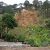
Communities need to prepare for increased landslide risk
12 Jun 2026
Media release: Te Whare Wānanga o Waitaha University of Canterbury | New UC-led research shows where future Cyclone Gabrielle-like storms could cause more landslides and how communities can reduce the risk.