
Study provides a step-change in understanding NZ’s groundwater
28 Nov 2025
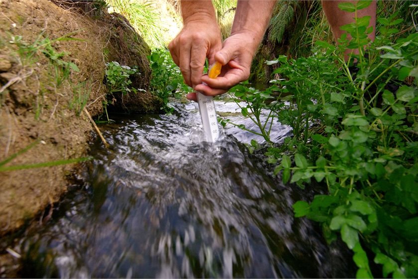
Media release | Earth Sciences New Zealand has developed a world-first National Groundwater Age Map and a powerful suite of tools to support the sustainable management of our hidden groundwater resources, from national through to local scales.
The six-year Te Whakaheke o Te Wai research programme has combined innovative techniques in environmental tracers and modelling, with mātauranga Māori, to reveal new insights about the age, source, flow and cultural values of the water in Aotearoa New Zealand’s underground aquifers.
Groundwater is critical for New Zealand’s freshwater security, providing 40% of our drinking water, and more than 80% of the water flowing through our rivers, streams and wetlands. It’s also a vital resource for our primary sector, with groundwater irrigation estimated to contribute more than $2 billion to New Zealand’s economy annually.
Groundwater age information can help identify where groundwater may be susceptible to contamination and holds insights to evaluate the sustainability of groundwater extraction and guide water management. Earth Sciences New Zealand developed the innovative National Groundwater Age Map from more than 1000 groundwater samples to provide an overview of groundwater age and groundwater/surface water interaction across the country.
Researchers found the groundwater supplying most of the wells was between one and 100 years old, however some deep wells in Taranaki and the Marlborough regions held water that was 40,000 years old. At the other extreme, Wairau had the youngest groundwater: water there took only two weeks to move through the aquifer system.
Younger systems can be vulnerable to contamination from live pathogens and nitrate loads, whereas older water presents a challenge with nitrate contamination potentially taking decades to work its way through the aquifer. The research offers practical insights for public health.
“Knowledge of water age and flow rates is important for managing potential contamination of drinking water. We’ve created a drinking water protection zone guideline to help protect wells from pathogens in the fast-flowing groundwater found in some of our aquifer systems, such as the Heretaunga Plains,” says programme co-lead and Principal Scientist Uwe Morgenstern.
The programme has also developed a National Groundwater Model to inform water management decisions. The national model incorporates data such as geology and soil characteristics, climate, surface water hydrology, groundwater levels, and groundwater age. It is available as an interactive map, integrating “Rapid Model Build” tools that can zoom in from national to regional to local scales. These numerical models can be used to test different scenarios.
“These tools allow decision-makers to build models more cost-effectively, so that they can answer environmental management questions more quickly, wherever they are needed,” says programme co-lead and Principal Scientist Catherine Moore.
Using modelling to address community concerns about the Paritua Stream at Bridge Pā
As part of wider work in the Heretaunga Plains, the team built a local-scale model to help address community concerns about the Paritua/Karewarewa Stream at Bridge Pā, a culturally significant stream running alongside two marae.
Mana whenua have observed declining water levels in the stream in recent years, although a long continuous record at Bridge Pā is still needed to quantify the detail of these trends. It ran dry in 2021 and again in early November 2025. When this happens, it makes it harder for mana whenua to collect mahinga kai.
“We lost a lot of our kokopu. Eels were stuck in holes. If you look at it in Māori eyes, our river is calling for help,” said Robert Turner, Bridge Pā spokesperson, about the 2021 event.
These low flow impacts occur in the sections of the Paritua/Karewarewa which naturally lose flow through the stream bed.
The Te Whakaheke o Te Wai team worked with Ngāti Kahungunu ki Heretaunga to incorporate mātauranga Māori into the models, which provided insights extending into the past beyond those we have from modern instrumental records. Historical evidence was also included, such as maps of past swampy areas and wetlands, the changing local land levels following the 1931 Napier earthquake, and changes following European settlement such as land clearances, gravel extraction, surface water diversions and irrigation. Together with Western science data (e.g. measurements of groundwater levels in wells, groundwater age tracer information, rainfall estimates), this has resulted in a powerful tool for exploring future stream restoration and water management options.
“We’ve essentially compiled a ‘biography’ of the Paritua Stream catchment, capturing the natural and artificial changes that have occurred over time. This allows us to design the model to answer specific questions raised by the community, such as “What did the stream used to be like in pre-European times?” and “What methods would restore the stream flow?” says Moore.
“The model gives a numerical voice to the community, empowering them to trust and contribute to the conversation about the management of the stream’s catchment.”
The models indicate the strongest influence on Paritua stream flow is rainfall, so even in pre-European times, during very dry periods, the stream would have likely ran dry at Bridge Pā. During the 1970s - 1990s the Paritua stream catchment was augmented by channelled surface irrigation (‘border dyke irrigation’) water sourced from the Ngaruroro River, which served to keep the stream flowing even during dry periods. The team explored the potential impacts of switching off well pumping in the catchment during a dry year, but found that while it would provide some relief, it would not prevent the stream from running dry.
Other restoration options identified as more likely to be effective were sealing the stream bed in those sections with highly permeable gravel, and bringing water into the catchment: either directly into the stream, or indirectly to feed a wetland.
While bringing water into the catchment directly or via wetlands can sustain flow during dry periods, the research also shows that long-term restoration will require attention to the chemical compatibility between source water and the stream bed. If the water added into the system is low in minerals, it may gradually dissolve the natural tufa (carbonate deposit) sealing in parts of the Paritua, increasing water loss through the stream bed over time.
The Bridge Pā model was part of a wider case study of the Heretaunga Plains, developed in partnership with Ngāti Kahungunu and Hawke’s Bay Regional Council.
“One of the things that has been missing for mana whenua in the past is the imbuing of our mātauranga into the models and tools that are used to manage water. Te Whakaheke o Te Wai has provided an opportunity for Ngāti Kahungunu to step in alongside of this process and reframe our focus and direction for water management going forward,” says Marei Apatu, Senior Executive Manager Te Kaihautū, Te Taiwhenua o Heretaunga, Ngāti Kahungunu.
Hawke’s Bay Regional Council Team Leader - Hydrology and Groundwater Science Simon Harper says that Te Whakaheke o Te Wai’s research has supported the council’s efforts to ensure sustainable management of the groundwater of the region.
“We’ve been incredibly fortunate as a community to have Earth Sciences New Zealand experts invest significant time and resources - at no direct cost to the rate payer - to provide independent analysis that’s helping us navigate a complex and often contested issue,” says Hawke’s Bay Regional Councillor Di Roadley.
print this story
Southern Ocean might be best place to fertilise for carbon dioxide removal
Today 12:15pm
Media release: Springer Nature | The Southern Ocean and parts of the Pacific near the equator may be the best places to fertilise if we want to remove the most carbon dioxide from the atmosphere while minimising the impact on the environment, according to international research.

Greenpeace calls for citizens assembly to reform electoral finance laws
Thu 30 Jul 2026
Media release | Greenpeace is calling on all political parties to support a citizens assembly to reform electoral finance laws in light of the alarming flood of political donations threatening to drown democracy in New Zealand.
Biochar market predicted to reach US$1.6 billion by 2035
Thu 30 Jul 2026
Media release: Transparency Market Research | Strong growth in the global biochar market will be driven by sustainable agriculture and carbon sequestration initiatives.
Culture shapes the meaning of sustainability, NZ study finds
Mon 27 Jul 2026
Media release: Bioeconomy Science Institute | Cultural context changes what sustainability means to people, a new New Zealand study finds.

New funding round opens for Auckland zero waste projects – $500k available
24 Jul 2026
Media release | Auckland Council is inviting applications for the 2026 Waste Minimisation and Innovation Fund (WMIF) with $500,000 available to support projects that reduce waste and increase recycling and reuse to help achieve Auckland’s goal of zero waste by 2040.

Turning waste into climate-resilient soils for communities
24 Jul 2026
Media release: University of Canterbury | Christchurch’s Red Zone is being used as a test bed to see whether biological wastes (biowastes) can help transform contaminated soil into climate-resilient soil.

Dry-year reliability obligation should fall on generators, not major electricity users – MEUG
23 Jul 2026
Media release | The Major Electricity Users' Group (MEUG) is urging the Government to redesign its proposed dry-year reliability obligation so responsibility for securing New Zealand's electricity supply rests with generators rather than major electricity users.

Greenpeace launches legal challenge against US$2.5bn expansion by Premier Beehive parent company JBS
23 Jul 2026
Media release | Greenpeace Netherlands has petitioned a Dutch court seeking to compel the world’s largest meat company JBS, to disclose information, in order to challenge its business policies in court. This includes its planned US$ 6 billion global expansion, of which almost half is earmarked for Nigeria.
Select committee report on resource management guts environmental protections
22 Jul 2026
Media release | Forest & Bird says the Environment Committee report on the biggest overhaul of resource management law in Aotearoa New Zealand in a generation is bad news for nature.

Open Letter: Exercise restraint on LNG import facility decision ahead of the election
21 Jul 2026
The Smart Energy Alliance respectfully urges the Government not to enter into a binding commercial agreement for a liquefied natural gas (LNG) import facility in the period immediately preceding the General Election.
