
New tool reveals shallow groundwater elevations
2 Apr 2025
Media release: NIWA | A new online tool that identifies areas at risk from groundwater flooding has been developed by New Zealand scientists.
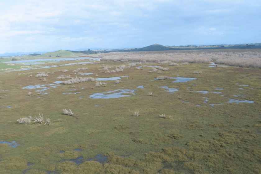
Groundwater flooding occurs when the water table rises close to the surface, causing issues even before the water visibly floods the ground.
The Shallow Groundwater Screening Tool, which identifies areas at threat from water table rises, will help hazard and land-use decision-makers understand the scale of the problem and which areas are likely to be the most vulnerable, says lead for the Future Coasts Aotearoa programme, NIWA Chief Scientist Coasts and Estuaries Dr Scott Stephens.
Groundwater - also known as the water table - rises with sea levels, particularly in coastal and low-lying areas, and it can be pushed even higher by persistent rainfall. Groundwater flooding is often overlooked as a threat, however it is a hazard that traditional flood defences such as stopbanks and seawalls cannot contain because the water comes up from underneath. When the groundwater rises, it can saturate soil and structures, weaken infrastructure, increase liquefaction risk and worsen surface flooding from heavy rainfall. As sea levels continue to rise, groundwater levels in the coast zone and close to tidal rivers will increase accordingly. Persistent heavy rain also pushes up the water table, a phenomenon which contributed to South Dunedin’s flooding in October 2024.
It's not all bad - shallow groundwater can also be beneficial for some ecosystems and for buffering droughts.
The first-of-its-kind online tool, developed as part of the NIWA-led Future Coasts Aotearoa research programme, shows areas that could be exposed to shallow groundwater hazards, right now, based on existing groundwater measurements, says Dr Stephens.
"Increased flooding events will be a real driver of change in many places. Rising groundwater will destabilise roads and damage buildings. It could make farming uneconomic. Stormwater pipes will be persistently full. Councils and decision-makers need an accurate picture of current shallow groundwater levels to prepare for future risks by identifying what areas could be exposed to shallow groundwater as sea levels continue to rise. This tool will be useful for local, district and regional councils, engineers, infrastructure providers, and rural communities, as well as individual citizens who want to make better-informed decisions for their future."
Water resource consultancy Kōmanawa Solutions created the tool. Its founder Zeb Etheridge says that we are interested in the shallow water table because that's the part of the groundwater system that's most affected by sea level rise.
"Two-thirds of New Zealanders live in coastal areas, meaning much of our infrastructure and land use falls within these vulnerable zones. Understanding this issue is critical for future planning."
The Kōmanawa Solutions team pulled together 2.4 million real-life readings of groundwater depth from around the country. To fill in the gaps, they used machine learning trained on factors that influence the water table, such as land elevation, soil type and nearness to waterways. Mr Etheridge describes the result as a risk screening tool to manage hazards, guide adaptation planning for existing land use choices, and plan future developments.
"Local authorities are likely to undertake more detailed assessments of the areas that are shown to be potentially exposed before making any significant decisions," he says. The tool is designed so that the certainty of detecting risky groundwater levels can be dialled up or down, as can the depth of groundwater that is of interest.
Further updates from the research team, which includes NIWA, Kōmanawa Solutions, GNS Science, and the University of Canterbury, are in development. These include projections of rising water tables as sea levels rise and land subsidence. The team will also investigate the risk of groundwater becoming saline as seawater infiltrates it.
The tool can be found at www.niwa.co.nz/shallow-
print this story

Greenpeace calls for citizens assembly to reform electoral finance laws
Today 11:30am
Media release | Greenpeace is calling on all political parties to support a citizens assembly to reform electoral finance laws in light of the alarming flood of political donations threatening to drown democracy in New Zealand.
Biochar market predicted to reach US$1.6 billion by 2035
Today 11:30am
Media release: Transparency Market Research | Strong growth in the global biochar market will be driven by sustainable agriculture and carbon sequestration initiatives.
Culture shapes the meaning of sustainability, NZ study finds
Mon 27 Jul 2026
Media release: Bioeconomy Science Institute | Cultural context changes what sustainability means to people, a new New Zealand study finds.
New funding round opens for Auckland zero waste projects – $500k available
Fri 24 Jul 2026
Media release | Auckland Council is inviting applications for the 2026 Waste Minimisation and Innovation Fund (WMIF) with $500,000 available to support projects that reduce waste and increase recycling and reuse to help achieve Auckland’s goal of zero waste by 2040.

Turning waste into climate-resilient soils for communities
Fri 24 Jul 2026
Media release: University of Canterbury | Christchurch’s Red Zone is being used as a test bed to see whether biological wastes (biowastes) can help transform contaminated soil into climate-resilient soil.

Dry-year reliability obligation should fall on generators, not major electricity users – MEUG
23 Jul 2026
Media release | The Major Electricity Users' Group (MEUG) is urging the Government to redesign its proposed dry-year reliability obligation so responsibility for securing New Zealand's electricity supply rests with generators rather than major electricity users.

Greenpeace launches legal challenge against US$2.5bn expansion by Premier Beehive parent company JBS
23 Jul 2026
Media release | Greenpeace Netherlands has petitioned a Dutch court seeking to compel the world’s largest meat company JBS, to disclose information, in order to challenge its business policies in court. This includes its planned US$ 6 billion global expansion, of which almost half is earmarked for Nigeria.
Select committee report on resource management guts environmental protections
22 Jul 2026
Media release | Forest & Bird says the Environment Committee report on the biggest overhaul of resource management law in Aotearoa New Zealand in a generation is bad news for nature.
Open Letter: Exercise restraint on LNG import facility decision ahead of the election
21 Jul 2026
The Smart Energy Alliance respectfully urges the Government not to enter into a binding commercial agreement for a liquefied natural gas (LNG) import facility in the period immediately preceding the General Election.
Tauranga secures international funding to support rangatahi climate action
16 Jul 2026
Media release: Tauranga City Council | Tauranga has been selected as one of 300 cities worldwide to receive funding through the Bloomberg Philanthropies Youth Climate Action Fund, creating new opportunities for local rangatahi to turn their climate action ideas into reality.