
Scientists develop tool to monitor coastal erosion in fine detail
21 Nov 2024
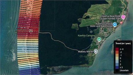 |
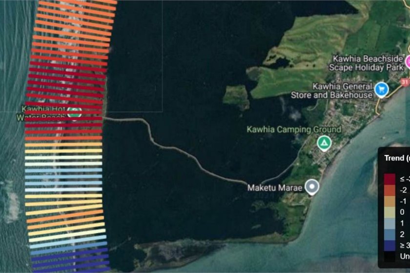
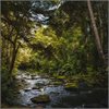
| Detail from CoastSat New Zealand |
Media release | An online tool developed by scientists at Waipapa Taumata Rau, University of Auckland allows for detailed monitoring of the nation’s coastal erosion from satellite imagery.
Around a map of New Zealand, dark red lines show the beaches eroding the most and clicking into any individual line gives detailed information going back to 1999. The data is updated once a month.
“This tool is a game-changer for anyone involved in coastal science or management,” says Professor Giovanni Coco, of the School of Environment. “Online beach monitoring for the whole of New Zealand is now a reality.”
The tool, called CoastSat New Zealand, can be used to monitor shoreline changes, assess coastal erosion, and support conservation efforts. For now, the tool is for specialists since more investment and tweaking would be needed for a version for the public.
Software engineer Nick Young of the University’s Center for eResearch and Coco built on the work of scientists at the University of New South Wales, who created an open-source software toolkit that pulls beach position data from publicly available satellite imagery.
Erosion hot spots exist in places such as Port Waikato while other places are accreting, such as Whatipu.
“As coastal areas face increasing pressures from climate change and human activity, tools like CoastSat New Zealand are essential for informed decision-making,” says Coco.
Google Earth Engine gives access to a growing archive of publicly available satellite imagery, providing the opportunity for global-scale analyses stretching back decades, Australian scientists led by Dr Kilian Vos said in a paper explaining their work.
“This project was made significantly easier by Kilian Vos providing the data and code freely online,” says Young.
print this story
Southern Ocean might be best place to fertilise for carbon dioxide removal
Fri 31 Jul 2026
Media release: Springer Nature | The Southern Ocean and parts of the Pacific near the equator may be the best places to fertilise if we want to remove the most carbon dioxide from the atmosphere while minimising the impact on the environment, according to international research.

Greenpeace calls for citizens assembly to reform electoral finance laws
Thu 30 Jul 2026
Media release | Greenpeace is calling on all political parties to support a citizens assembly to reform electoral finance laws in light of the alarming flood of political donations threatening to drown democracy in New Zealand.
Biochar market predicted to reach US$1.6 billion by 2035
Thu 30 Jul 2026
Media release: Transparency Market Research | Strong growth in the global biochar market will be driven by sustainable agriculture and carbon sequestration initiatives.
Culture shapes the meaning of sustainability, NZ study finds
Mon 27 Jul 2026
Media release: Bioeconomy Science Institute | Cultural context changes what sustainability means to people, a new New Zealand study finds.
New funding round opens for Auckland zero waste projects – $500k available
24 Jul 2026
Media release | Auckland Council is inviting applications for the 2026 Waste Minimisation and Innovation Fund (WMIF) with $500,000 available to support projects that reduce waste and increase recycling and reuse to help achieve Auckland’s goal of zero waste by 2040.

Turning waste into climate-resilient soils for communities
24 Jul 2026
Media release: University of Canterbury | Christchurch’s Red Zone is being used as a test bed to see whether biological wastes (biowastes) can help transform contaminated soil into climate-resilient soil.

Dry-year reliability obligation should fall on generators, not major electricity users – MEUG
23 Jul 2026
Media release | The Major Electricity Users' Group (MEUG) is urging the Government to redesign its proposed dry-year reliability obligation so responsibility for securing New Zealand's electricity supply rests with generators rather than major electricity users.

Greenpeace launches legal challenge against US$2.5bn expansion by Premier Beehive parent company JBS
23 Jul 2026
Media release | Greenpeace Netherlands has petitioned a Dutch court seeking to compel the world’s largest meat company JBS, to disclose information, in order to challenge its business policies in court. This includes its planned US$ 6 billion global expansion, of which almost half is earmarked for Nigeria.
Select committee report on resource management guts environmental protections
22 Jul 2026
Media release | Forest & Bird says the Environment Committee report on the biggest overhaul of resource management law in Aotearoa New Zealand in a generation is bad news for nature.

Open Letter: Exercise restraint on LNG import facility decision ahead of the election
21 Jul 2026
The Smart Energy Alliance respectfully urges the Government not to enter into a binding commercial agreement for a liquefied natural gas (LNG) import facility in the period immediately preceding the General Election.