
Coastal inundation enquiries increase on the West Coast
Today 12:00pm
By Vihan Dalal, Local Democracy Reporter
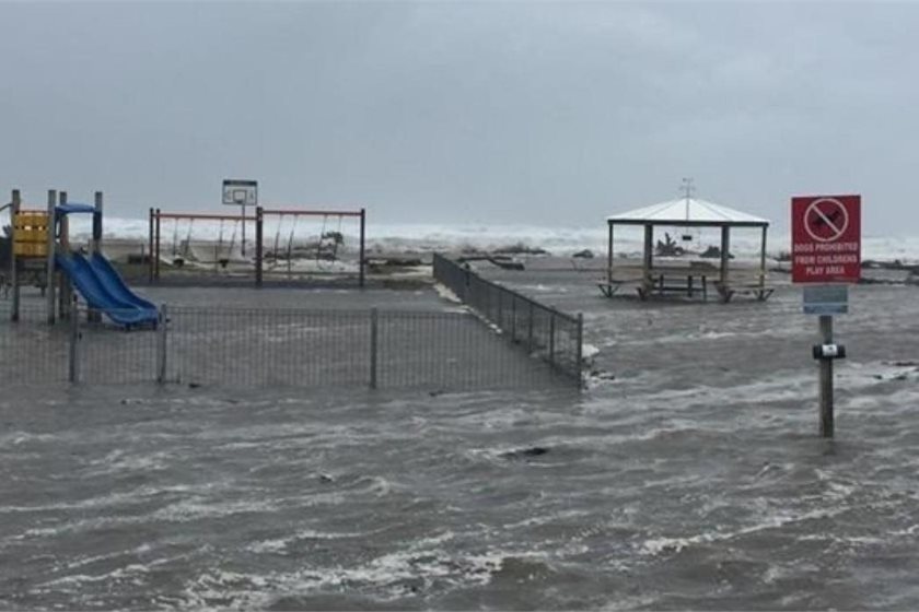
The West Coast Regional Council is seeing more inquiries about coastal inundation. A report tabled at the Environmental Management Committee meeting last week showed coastal inundation was the second-most common inquiry received by the council after flooding.
The council believed the increase was due a growing awareness among homebuyers and insurance companies of the coastal hazard risk.
Flooding inquiries in the 2023-24 year numbered 30, and under 25 in the following year.
In contrast, the number of inquiries for coastal inundation throughout the West Coast doubled in the same period, from seven to 15.
The report came as sea protection work at the Greymouth suburb of Cobden remains at a standstill, with both the Grey District Council and the regional council trying to obtain government funding for it.
Low lying parts of Cobden, including on the Range Creek catchment, has a history of flooding. The suburb also has suffered numerous coastal inundation events in the past 70 years from the Grey River mouth and north along Dommett Esplanade -- and as recently as June 2022.
Cyclone Fehi in February 2018 sparked a major environmental disaster when it opened up the historic Greymouth landfill on the shoreline, spewing thousands of pieces of plastic rubbish along the beaches.
It resulted in a major piece of protection work and the abandonment of public vehicle access to a large section of seafront.
The Climate Change Commission recently released a case study on Westport outlining the impact of climate change on that town in the aftermath of the 2021 floods which led to 2000 people evacuating their homes.
WCRC environmental science group manager Shanti Morgan said the council has since July 2023 received a handful of inquiries about coastal inundation from Westport, Carters Beach and Cobden.
Ms Morgan said attributed it to a growing need from homebuyers and insurance companies to understand the coastal hazard risk in the area.
"It is not entirely clear what has led to this increase but is likely to reflect a growing awareness ... to understand hazard exposure in coastal areas."
While flooding remains the primary natural hazard on the West Coast, the region is also vulnerable to coastal inundation in some urban areas, she said.
"A prime example is the Granity area north of Westport where some properties have been flooded and coastal erosion has led property owners to install their own rock protection."
Ms Morgan cited the compulsory inclusion of identified coastal hazard areas in the Te Tai o Poutini Plan combined district plan for the Coast as another reason for an upswing in coastal hazard inquiries.
Those inquiring were provided with information to help them determine their exposure to inundation risks.
"Depending on the detail of the inquiry, council will typically provide relevant hazard maps, from either TTPP, or more recently from our online Natural Hazards portal. While not developed for use at the individual property level, these maps can help the inquirer to determine their risk exposure," Ms Morgan said.
LDR is local body journalism co-funded by RNZ and NZ on Air
![]()
print this story

EU climate policy ‘won’t survive’ its clash with EU farmer politics
Today 12:00pm
By Pattrick Smellie | European Union climate change policy is on a collision course with European farmer politics, exacerbated by the rise of populist right-wing parties in the UK and the Continent, says Oxford University professor of geosystem science, Myles Allen.

Lack of finance stalling sustainable innovation – report
Today 12:00pm
By Shannon Morris-Williams | A lack of access to suitable finance is threatening growth in New Zealand's sustainable innovation sector, despite strong confidence and ambitious expansion plans among purpose-driven businesses, according to a new report.

Lower Hutt among five cities in global climate risk initiative
Today 12:00pm
By Justin Wong, Local Democracy Reporter | Lower Hutt is one of five cities around the world picked for a global climate project to help vulnerable people respond to extreme climate risks.

Media round-up
Today 12:00pm
In our round-up of climate coverage in local media: A legal expert labels the government's climate law change "constitutionally abhorrent", the first critical minerals project has applied for fast-track, and warming winters are changing New Zealand’s landscapes.

Treasury says 2030 climate target could cost $5 billion
Thu 11 Jun 2026
By Liz Kivi | Treasury is predicting it could cost between $4.4 and $5 billion to buy the offshore mitigation needed to meet New Zealand’s 84-96 million tonne emissions reduction shortfall for its 2030 target under the Paris Agreement.

LNG imports might not be needed for 'dry year' security: redacted report
Thu 11 Jun 2026
By Oli Lewis | The need for imported liquefied natural gas to provide security of supply in a dry year is low, according to newly released modelling, with some scenarios featuring higher levels of renewable generation requiring no gas imports at all.
Govt backs faster uptake of on-farm emissions tools with $51m fund
Thu 11 Jun 2026
By Shannon Morris-Williams | The Government is investing up to $51 million over three years to help accelerate the uptake of on-farm emissions reduction technologies, with a new AgriZeroNZ initiative aimed at getting proven tools into the hands of farmers sooner.

Once-in-a-century floods routine as sea levels rise due to climate change
Thu 11 Jun 2026
By Shannon Morris-Williams | A coastal flood expected to occur just once every 100 years is now hitting Wellington about twice a year, according to new international research that scientists say offers clear evidence of how climate change is already reshaping New Zealand's coastline.

Liebreich: Electrify first, insure second
Thu 11 Jun 2026
New Zealand is having an argument about gas while the rest of the world is building an electric future. That, in essence, is the challenge Michael Liebreich left behind after a visit to Wellington last week.