
Maps of Europe predict scale of climate catastrophe
12 Feb 2020


A SERIES of detailed maps have laid bare the scale of possible forest fires, floods, droughts and deluges that Europe could face by the end of the century without urgent action to adapt to and confront global heating.

It’s too hot in Europe – again
Fri 26 Jun 2026
Europeans are experiencing their second heat wave this summer. One climate scientist called the weather event a “sad inevitability.”

French farmers suffer arid crops, heat-stricken animals
Fri 26 Jun 2026
France's current heatwave is taking a toll on farmers, who are seeing livestock die and are racing against time to harvest cereals without sparking fires in the tinder-dry crops.

France records hottest day ever as 40 people drown across country
Thu 25 Jun 2026
France has registered its hottest day on record as 40 people across the country were confirmed to have drowned while swimming in unsupervised areas over the last few days.

Half of France under red heat alert as alcohol banned at street music festival
Tue 23 Jun 2026
France has issued red heatwave alerts for around half the country including Paris for Monday as a heatwave pushes temperatures towards record levels.

EU greenhouse gas emissions rose in 2025, data shows
19 Jun 2026
The European Union did not manage to reduce its planet-warming emissions last year, with preliminary data showing a slight increase in pollution levels compared to 2024.
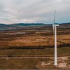
Ukraine hopes renewables can Russia-proof power grid
19 Jun 2026
Quick to build and able to power a small city, the Oriv wind farm in western Ukraine is exactly the kind of project Kyiv hopes will backstop its power grid against routine Russian strikes.

Steel and chemicals giants demand freeze to EU’s flagship climate policy
17 Jun 2026
The attack on the Emissions Trading System is among industry's most direct calls yet for the EU to change course on climate.

Climate change reshapes Spain's rockfall risk as frost weathering moves uphill
16 Jun 2026
Climate change is altering where and when rocks are most likely to fracture across Spain, according to new research that suggests warming temperatures are redistributing a key process responsible for breaking down mountain landscapes.

EU agrees stronger price controls for new carbon market
12 Jun 2026
The European Union agreed stronger measures to control prices in its new carbon market early on Thursday, responding to governments' concerns that the emissions-cutting initiative could increase fuel bills.

Airline CEOs warn EU plan to expand carbon costs will raise fares
10 Jun 2026
Europe's biggest airlines have urged the European Union not to extend its Emissions Trading System to cover international flights, warning the move would raise ticket prices, a letter seen by Reuters showed.