
What the coming El Niño climate pattern means for NZ in a warming world
Today 11:00am
Jim Salinger, Te Herenga Waka – Victoria University of Wellington
After the planet’s 11 hottest years on record, scientists are warning the return of an El Niño climate pattern could push global temperatures even higher.
The World Meteorological Organisation reported that the past decade has been the warmest observed, with rising greenhouse gas emissions driving record ocean heat, melting ice and more extreme weather.
On top of those findings comes the growing prospect of El Niño, which could emerge by New Zealand’s spring and amplify the effects of global warming in the months beyond.
At this stage, the event is expected to be moderate, resulting in global mean sea surface temperatures of around 1C warmer than average. However, there is still considerable uncertainty in how it will develop.
For the planet, El Niño can bring a wide range of damaging impacts, from wildfires and drought in some regions to heavy downpours and flooding in others.
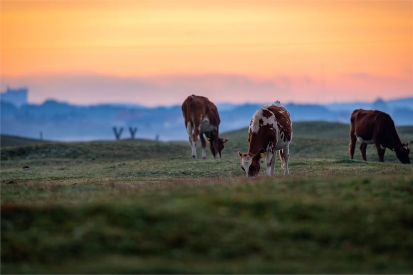
It can also have significant impacts for New Zealand and its primary sector. Some stand-out events – such as in 1982–83, 1997–98 and 2015–16 – caused severe droughts that cost the economy hundreds of millions of dollars.
Notably, it follows a rain-soaked start to the year across much of New Zealand, partly owing to the lingering, warm-and-wet influence of El Niño’s climate driver counterpart: La Niña.
As that La Niña fades out over coming weeks, as it is forecast to, scientists will be monitoring the potential seesaw-like shift to El Niño.
But, in New Zealand’s part of the world particularly, such swings do not play out in isolation: other large-scale patterns are likely to influence how El Niño’s effects are felt.
El Niño explained
The name El Niño – meaning “Christ Child” – was given by Peruvian fishers who noticed warm waters appearing off their coast around Christmas. Its global significance was recognised over time.
It occurs when the usual trade winds across the tropical Pacific weaken, sometimes reversing direction, allowing warmer water to spread eastward and raise sea surface temperatures. In contrast, La Niña features stronger trade winds and cooler waters.
Together, these phases form the El Niño/Southern Oscillation (ENSO), which typically cycles every two to seven years and is measured by sea surface temperatures in the central equatorial Pacific.

This graph illustrates how El Niño climate patterns have historically coincided with warmer mean global sea surface temperatures, while its counterpart La Niña has come with the opposite effect. The data was sourced from the Copernicus Climate Change Service and the US National Oceanic and Atmospheric Administration.
At a global scale, El Niño events make for warmer years by raising air temperatures and reducing the rate at which the ocean absorbs heat.
They tend to bring warmer conditions to parts of Asia and North America, wetter weather to parts of the United States and South America, and drier conditions in Australia and parts of Africa.
In New Zealand, El Niño typically shifts atmospheric circulation patterns. Winters tend to feature more southerly winds, spring more south-westerlies and summer more westerlies.
This generally leads to cooler conditions overall, although eastern areas such as Wairarapa, Hawke’s Bay and Gisborne can still experience warmer than average summers.
Rainfall patterns also change. El Niño is often associated with drier conditions in the north and east of both islands, and wetter conditions in Southland and along the West Coast of the South Island.
By contrast, La Niña tends to bring warmer temperatures and different regional rainfall patterns, often with wetter conditions in the north and east. Because El Niño produces a clearer signal for New Zealand, it is usually more predictable.
The wider picture
Alongside ENSO, longer-term climate variability also plays a role.
Another cycle called the Interdecadal Pacific Oscillation (IPO) resembles ENSO and similarly influences patterns across the Pacific Basin, but operates on timescales of 20 to 30 years.
In its positive phase, warmer-than-average sea surface temperatures occur in the central equatorial Pacific, while cooler conditions prevail elsewhere in the basin. The opposite occurs in the negative phase.

The Interdecadal Pacific Oscillation (IPO) is a climate pattern that tracks long-term shifts in ocean temperatures across the Pacific. In its positive phase, warmer waters sit in the central Pacific (2), with cooler waters to the north (1) and south (3); the pattern reverses in its negative phase. The colour scale shows temperature differences from average, with reds indicating warmer-than-normal waters and blues cooler-than-normal conditions.
The IPO can either amplify or dampen the effects of global warming. In New Zealand, positive phases have tended to slow regional warming, while negative phases have accelerated it.
Since 1998, the IPO has been in a negative phase. During this period, New Zealand’s warming rate has increased markedly, from about 0.14°C per decade in earlier decades to around 0.27°C per decade more recently.

The Interdecadal Pacific Oscillation (IPO) is a climate pattern that shifts between positive and negative phases over decades. Values above zero indicate a positive phase, while values below zero indicate a negative phase, each linked to different patterns of ocean temperatures and climate. These shifts influence how quickly New Zealand warms, with recent decades dominated by a negative phase that has tended to accelerate regional warming.
Another important influence is the Southern Annular Mode (SAM), which affects the strength and position of westerly winds around New Zealand.
In its positive phase, high-pressure systems tend to dominate, pushing the westerly winds further south and bringing calmer, warmer conditions. This can lead to drier weather in the west and south, but wetter conditions in the north.
In its negative phase, lower pressure dominates, bringing stronger westerlies, cooler temperatures and wetter conditions, particularly in western regions.
SAM operates year-round but has its strongest effects in summer, interacting with both ENSO and the IPO.
How these three drivers play off one another will ultimately influence what unfolds in the coming seasons.
With El Niño expected to develop over winter, warmer sea surface temperatures will spread across the Pacific. The IPO, meanwhile, remains firmly in its negative phase, meaning warmer conditions are likely to persist around New Zealand.
At the same time, SAM is expected to fluctuate between positive and negative phases, although it has shown a tendency toward more positive conditions as the climate warms.
Together, these influences point toward the possibility of a significant El Niño event unfolding against the backdrop of a steadily warming planet.
Whether this evolves into another severe event for New Zealand remains to be seen. The climate of each season, after all, carries its own distinct personality.
But, coming on the back of the world’s warmest period on record, it warrants our close attention.![]()
Jim Salinger, Adjunct Research Fellow, Te Herenga Waka — Victoria University of Wellington
This article is republished from The Conversation under a Creative Commons license. Read the original article.
print this story

NZ prepares to join ‘gold rush’ for white hydrogen
Today 11:00am
By Pattrick Smellie | New Zealand may be close to commercialising the capture and use of naturally occurring ‘white’ hydrogen, with investment plans for developments in the Wairarapa region picking up pace in response to spiralling oil prices.

Govt’s relief package risks entrenching fossil fuel dependence, critics warn
Today 11:00am
By Shannon Morris-Williams | The Government’s $373 million fuel relief package is facing criticism for propping up petrol use rather than reducing demand, as prices surge and some experts predict fuel shortages due to conflict in the Middle East.
Gas sector asks Govt to back biomethane
Today 11:00am
The gas sector has asked the Government to back a much more active push into biomethane, arguing renewable gas made from waste and other organic material could eventually supply more than half of New Zealand's remaining natural gas demand.
Northland could set pace on rural climate resilience – study
Today 11:00am
By Shannon Morris-Williams | Taitokerau Northland has the foundations to lead New Zealand in rural climate resilience, but unlocking that potential will require better coordination, targeted investment and practical, region-specific support, a new study has found.
Activists occupy controversial gold drilling site
Today 11:00am
By Max Frethey, Local Democracy Reporter | Opposition in Golden Bay to a controversial gold mine at Sams Creek has flared up over the weekend after several activists briefly occupied a drilling site.

The decarbonisation agenda is (re)writing itself
Tue 24 Mar 2026
By Pattrick Smellie | COMMENT: There’s one thing that a lot of greenies, as he would call them, get wrong about Resources Minister Shane Jones.

Climate warnings mount as 2025 ranks among hottest years on record
Tue 24 Mar 2026
By Shannon Morris-Williams | The world is entering an era of sustained record heat, with 2025 confirmed as one of the hottest years ever recorded and the past decade the warmest on record, as scientists warn climate impacts are accelerating.

‘Significant’ shift as EECA backs commercial battery storage
Tue 24 Mar 2026
By Shannon Morris-Williams | The Energy Efficiency & Conservation Authority is preparing to roll out co-funding for commercial battery storage projects, targeting businesses ready to deploy systems that can ease pressure on the grid.

Top scientist speaks out against Trump regime’s attack on premier research centre
Mon 23 Mar 2026
By Liz Kivi | Kevin Trenberth, one of the world’s leading climate scientists, now based in New Zealand, has told the Trump administration he is “appalled” at its attempt to break up the international research centre he has been associated with for nearly 50 years.